
Features
-
SC-70 provides a high system accuracy for the heading of the ship, 0.4°
Provides highly accurate heading data for Autopilot, Radar, ARPA, Scanning Sonar, Current Indicator, Chart Plotter, ECDIS and Autopilot
●0.25° (with SC-130)
Ideal for medium to large vessels navigating in crowded ports and making precise maneuvers, such as berthing.
●0.4° (with SC-70)
Ideal for small to medium boats requiring highly accurate heading . -
Utilizes GNSS such as GPS, Galileo and GLONASS for high precision
・SBAS compatible (EGNOS,WAAS, MSAS)
・Provide precise data for SOG, COG, ROT and L/L
・Eliminating the problem of not having enough satellites at hand by using multiple types of satellites -
Speed on 3 axis (Bow, stern and longitudinal) for safe navigating and berthing
-
Type-approved as THD, GPS and ROTI*. Complying with the IEC, ISO requirements (For Solas Vessels)
IMO MSC.116(73) •IMO MSC.112(73) •IMO MSC.526(13) •IMO A.694(17)
IMO MSC.97(73) •IMO MSC.191(79) •IMO MSC.302(87) •IEC 60945 Ed.4
IEC 62288 Ed.2 •IEC 61162-1 Ed. 4 •IEC 61162-2 Ed.1 •IEC 61162-450 Ed.1
IEC 61108-1 Ed.2 •ISO 22090-3 Ed.2 •ISO 20672 Ed.1
* requires the RD-50 as a display unit -
Easily integrated into the existing shipboard network via Ethernet
-
Rapid follow-up rate 40°/S
・Twice the IMO high speed craft requirement, 20°/s -
Maintenance free and no recurring cost as there are no mechanical parts
-
Super short starting time - 90 seconds
・Once the power is on, it takes about 90 seconds only to start
(The starting time will slightly differ depending on the equipment location) -
Easy to retrofit by using existing antenna cabling
・For SC-50/55/60/110/120 (The LAN_CNV option Kit is necessary) -
Precision Pitch/Roll data in Analog and Digital formats for vessel stabilization, SONAR, etc.
-
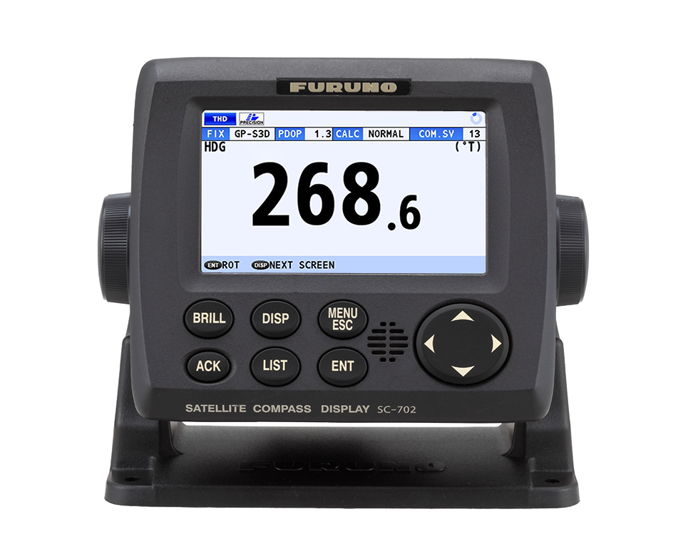
Display modes
THD mode
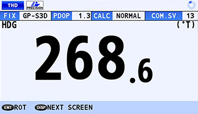
- Display the heading (HDG) of the ship
Speed mode
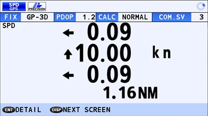
- 3-axis speed of the ship: Bow, Stern and longitudinal
(non-IMO type only)
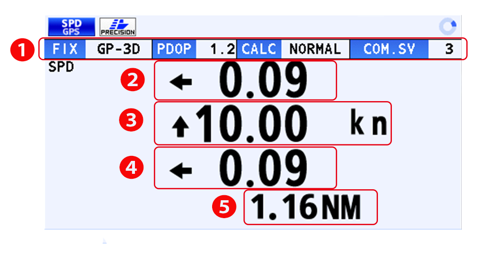
① Current selected mode (SPD or THD), integrity status and common satellite
② Transverse speed at bow position
③ Longitudinal speed
④ Transverse speed at stern position
⑤ Distance travelled
Navigational data screen
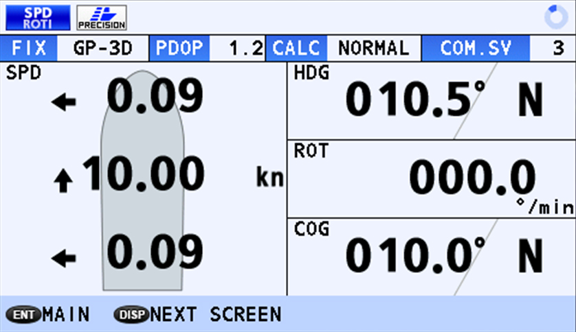
- 3-axis speed, as well as the Heading, Rate Of Turn and
Course Over Ground can be Grasped at a glance
(non-IMO type only)
GPS integrity mode
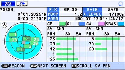
- GPS
- SBAS signal status
ROTI mode
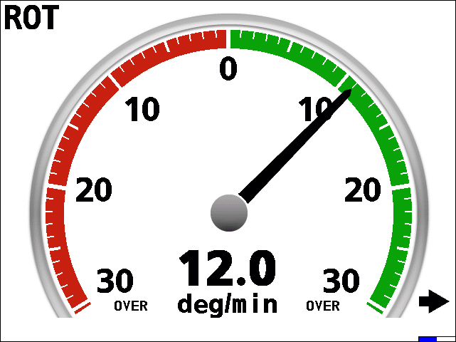
- Rate Of Turn Indicator displaying on the RD-50 (ROTI Display unit approved for SOLAS vessels)
Specifications
GENERAL
- Display
- 4.3-inch color LCD, 95.04 (W) x 87.12 mm (H)
480 x 272 dots (WQVGA) - Heading Accuracy
- 0.4
- Heading Resolution
- 0.1°,0.01°,0.001° (select from menu)
- Follow-up
- 40°/s
- Settling time
- 90 s approx. (typical)
- Position Accuracy
- GPS 10m approx. (2DRMS, HDOP<4)
DGPS 5m approx. (2DRMS, HDOP<4)
WAAS 3m approx. (2DRMS, HDOP<4)
MSAS 7m approx. (2DRMS, HDOP<4) - Interface
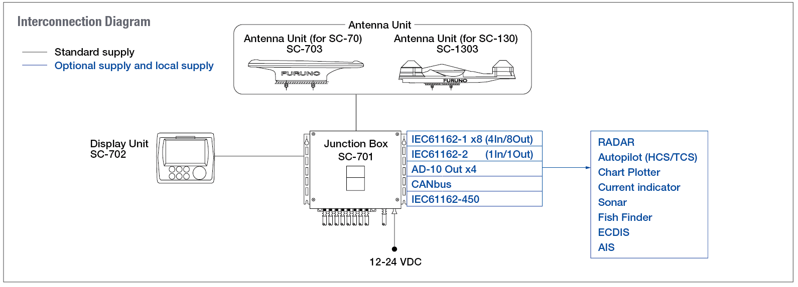
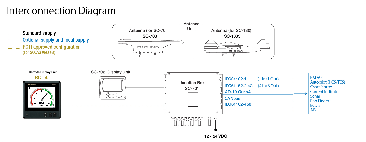
- Number of ports (junction box)
IEC61162-2: 1 port (IN: 1,OUT: 1)
IEC61162-1: 8 ports (IN: 4,OUT: 8)
External beacon input (DATA5 port): RTCM SC-104 V2.3 (RS-485), ITU-R M823
CANbus: 1 port
AD-10: 4 ports, for heading output
RS-485 : 1 port, for display unit connection
LAN (IEC61162-450) :Ethernet, 100Base-TX, RJ45 connecter - Temperature
- Antenna Unit : -25°C to +55°C (storage: -25°C to +70°C)
Display Unit/ Junction Box : -15°C +55°C - Waterproofing
- Antenna Unit : IP56
Display Unit : IP22 (IP35 : option)
Processor Unit : IP20 (IP22 : bulkhead mount) - Power Supply
- 12-24 VDC: 2.1-1.1 A (included Antenna Unit and Display Unit)
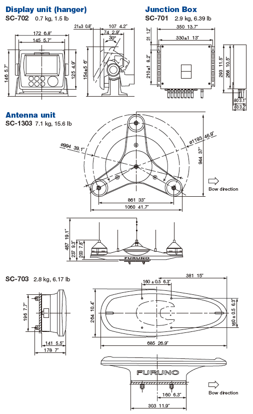
- Weight
- Display Unit : 0.7 kg
Junction Box : 2.9 kg
Antenna Unit (SC-703) : 2.8 kg
Drawing
Interconnection Diagram
Equipment List
Standard
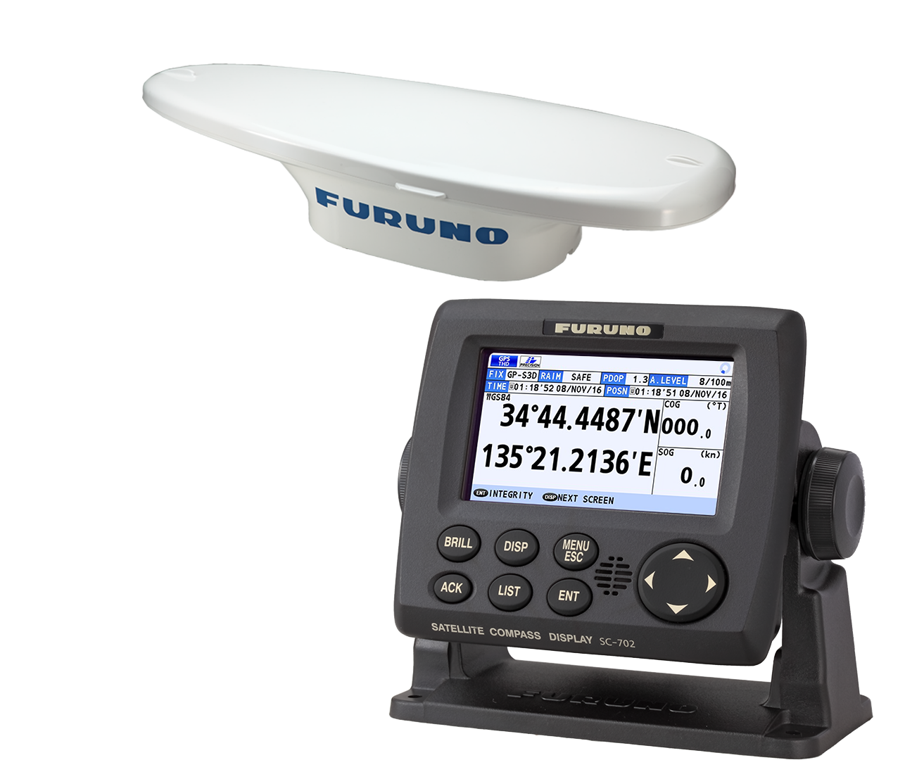
- Antenna Unit SC-703 x 1
- Display unit SC-702 x 1
- Junction Box SC-701 x 1
- Installation Materials
Option
- AC/DC Power Supply UnitPR-240
- Alarm Monitoring
IF-2503 - Interface Unit
IF-NMEA SC - Remote DisplayRD-50
- Connector (waterproof)FRU-RJ-PLUG-ASSY
- Modular ConnectorMPS588-C
- LAN_CNV KitOP20-47/48
- Cable assemblyM12-05BFFM-010/020/060
- Connector (NMEA)LTWMC-05BFFT-SL8001
LTWMC-05BMMT-SL8001
SS-050505-FMF-TS001